Arboreal Tree
Have you ever wondered how tall a tree is? Just pick up your phone and download our app — no extra tools needed.
Arboreal Tree is the world's first AR-application that lets you measure, scan and create point clouds and 3D objects of trees. Measure height, diameter, crown shape and much more.
- Great accuracy
- Easy to use
- The best tool is the one that's always with you
Try 5 free measurements — no subscription required
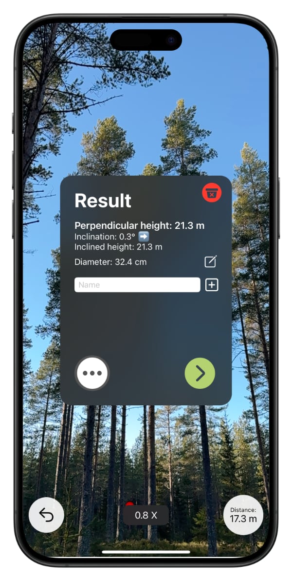
How does it work?
Go near the tree and use the button to mark the tree
Move a few meters away from the tree and mark the base and the top of the tree.
The height of the tree is displayed on the screen.
What our users say about the app:

It is convenient and simple to use. The accuracy is good compared with laser height meters
Peder Israelson
Forester, Sveaskog

Neat and simple to use. Now I always have a height meter with me when I am outdoors
Malin Norderman
Forest Nature Conservation Specialist, Sveaskog

I think the app works very well, I have tested it against the Haglöfs Vertex altimeter and it gives a similar result
Jonas Jonzen
Forestry Researcher Engineer, SLU, Swedish University of Agricultural Sciences
Ready to measure trees?
Try 5 free measurements — no subscription required
Basic and Premium
Arboreal Tree can be used to measure many parts of the tree and offers many features. We offer two different plans, Basic and Premium. Find out what suits you best.
| Feature | Basic | Premium |
|---|---|---|
| Measure height, crown height, crown width, inclination and diameter | ||
| Save name, comment and GPS coordinates | ||
| Save and export images and measurements as .csv | ||
| LiDAR support, zoom and crosshair options | ||
| Imperial and metric system | ||
| Sync data and up to 200 images to the cloud | ||
| Save 12 MP images | ||
| Measure crown shape | ||
| Emlid Reach RX / RX2 support | ||
| Save up to 2,000 images in the cloud | ||
| Multi-tree sessions in one coordinate system | ||
| Export point clouds and 3D models | ||
| REST API for integration with own systems |
Ready to measure trees?
Try 5 free measurements — no subscription required
Arboreal Tree Premium
Professional tree measurement for urban forestry
Scan, measure, and export — multiple trees, one session, one coordinate system.
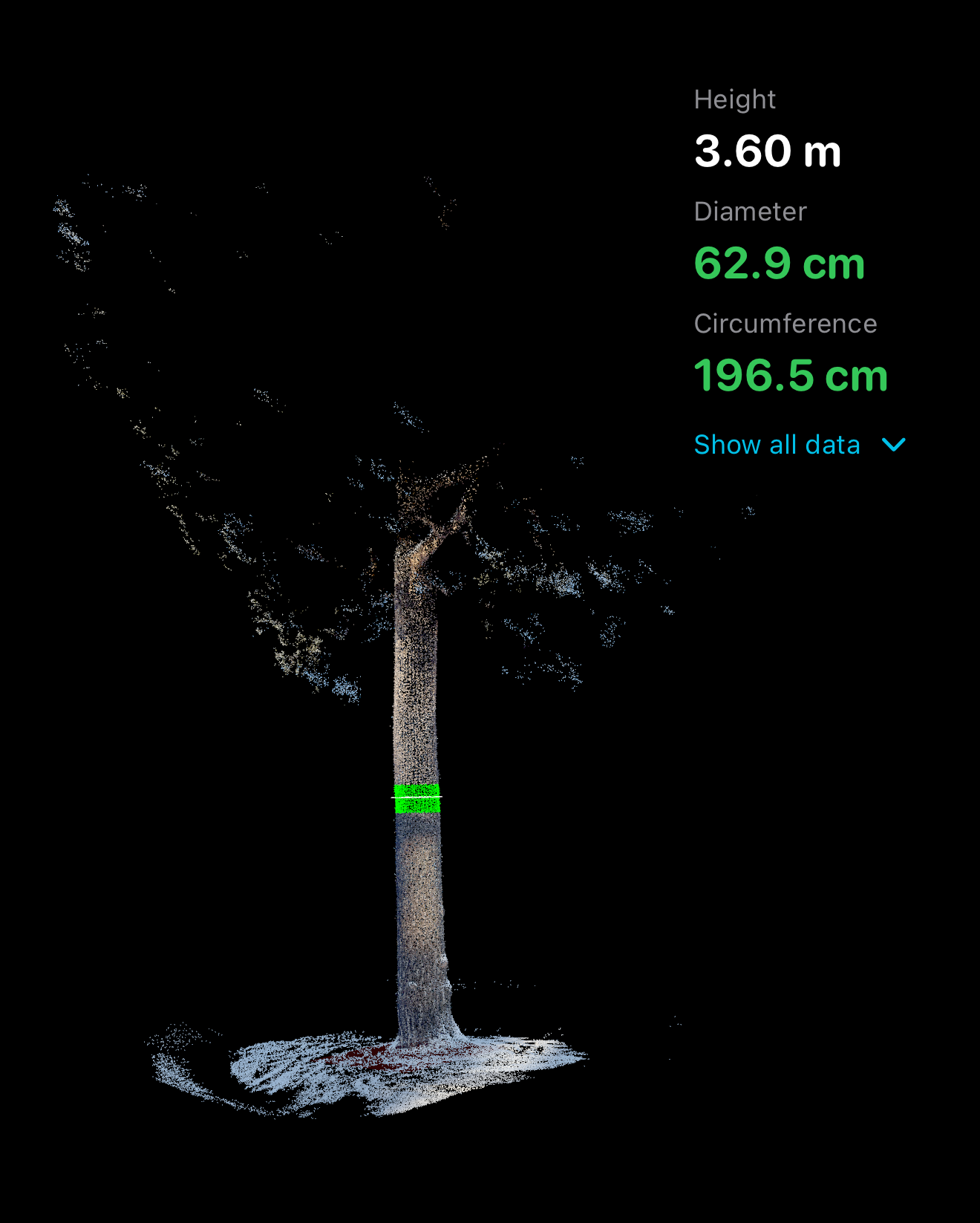
Visualize, measure diameter and export the point cloud.
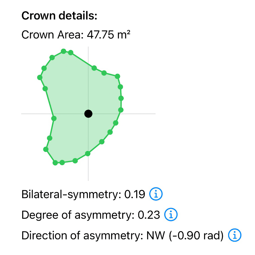
Measure the crown shape by walking under the tree and collecting the outer perimeter — the app calculates area and asymmetry.
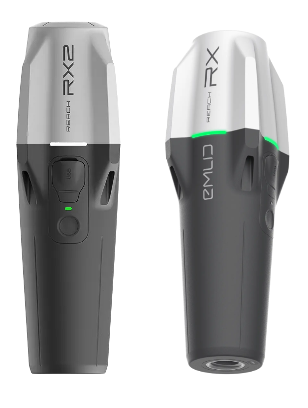
Premium supports Emlid Reach RX/RX2 GNSS that gives centimetre-level accuracy on the position of the centre of the tree. The device is connected with Bluetooth and requires correction signals from the internet in order to get the highest accuracy.
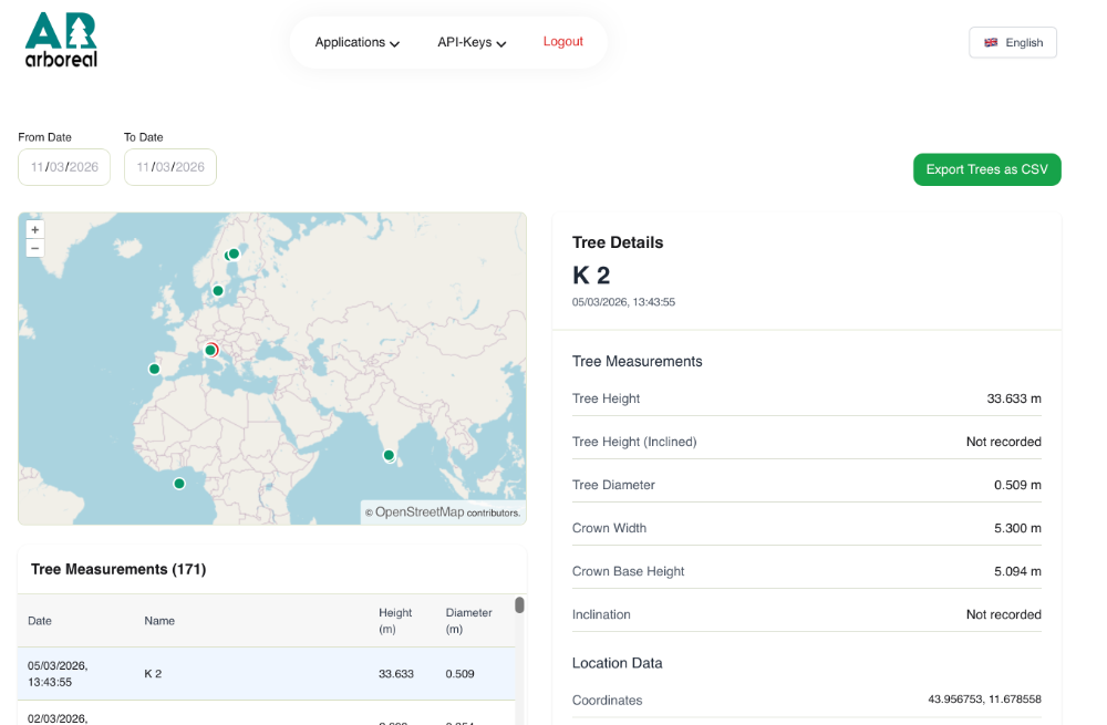
All data is synced to the cloud and available for download. We also offer REST APIs for integration with your own systems.
Premium Features
Premium unlocks the tools that turn Arboreal Tree into a complete field measurement system for arborists, city foresters, and environmental consultants.
Point Cloud Export
Export detailed 3D point clouds to CloudCompare or other modelling software for further analysis and visualisation.
Circumference in Point Cloud
Measure trunk circumference directly in 3D — no tape needed. Accurate, repeatable, and documented in the point cloud.
Crown Shape Analysis
Quantify crown shape and asymmetry for risk assessment, pruning planning, and documentation.
Multi-Tree Sessions
Measure multiple trees in a single session with one coordinate system and one unified export. Ideal for inventories.
Emlid GNSS Support
Connect Emlid Reach RX / RX2 for centimetre-level positioning. Place every tree with survey-grade accuracy.
Images
Save and sync up to 2,000 high-resolution images to the cloud. Document conditions, defects, and surroundings.
API Integration
Integrate Arboreal Tree data into your own systems via our REST API — available for individual users and organisations.
Contact us: sales@arboreal.se
Who Premium Is For
Whether you are assessing a single tree or managing a city-wide inventory, Premium gives you the tools to work faster and document better.
- Municipal arborists and city foresters managing urban tree inventories
- Professional foresters who need accurate, documented data at the individual tree level
- Consulting arborists conducting risk assessments and site documentation
- Environmental consultants working on planning and impact assessments
- Landscape architects needing precise tree data for design projects
- Research teams collecting standardised tree measurement data
Frequently Asked Questions
No FAQ items found related to height measurement